DeepSeek Harness Plugin "Footprints": Turn Your Photo Album into a 3D Earth
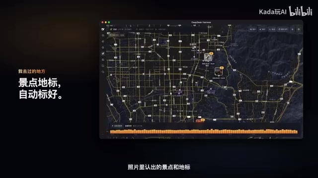
The "Footprints" plugin projects photo coordinates onto a nighttime Earth, turning your album into a replayable life map.
"Footprints" is a DeepSeek Harness plugin that reads photo geolocation metadata, lights up places you've photographed on a nighttime globe, and lets you zoom from the globe down to streets and mountains. It auto-labels landmarks, sorts photos by quality, organizes trips into journeys with "Story Camera" replays, and offers "That Day in Years Past" plus natural language search like "Kyoto 2023 cat" with the map flying to results. The library is read-only and indexing stays local.
When Photos Return to the Earth
There are thousands of photos piled up in your phone's album, but most people rarely get to truly "see" the paths they've traveled beyond the occasional scroll. A DeepSeekAd Harness plugin called "Footprints" (足迹) that appeared on Bilibili attempts to solve exactly this problem: re-projecting the location where each photo was taken onto a nighttime globe, turning memories from flat pixels into a tangible geographic trail.
Its core logic isn't complicated—photos themselves carry geolocation metadata, and the plugin aggregates and visualizes these coordinates, layering on storylines, landmark recognition, and natural language search around them. But it's precisely this "simple" reorganization that transforms the album from passive storage into a life map you can replay.
From Globe to Street: A Layered Spatial Narrative
When you open "Footprints," every place where you've taken a photo lights up on the surface of the nighttime Earth. This illumination isn't a static scatter plot but a spatial entry point with narrative: zoom in, and photos pop out from the places you've been; zoom in further, and the view pushes all the way down to streets, buildings, and rolling mountains.
The plugin automatically recognizes scenic spots and landmarks in your photos and labels them on the map. Click a marker, and you see all the images you've captured at that location. It's like giving every photo its own personal Wikipedia guide—a place isn't just a coordinate, but comes with cultural and geographic context.
EXIF and Photo Geolocation Metadata
The geographic location recorded in photos comes overwhelmingly from EXIF (Exchangeable Image File Format) information written by cameras or phones. EXIF is a common metadata standard for digital photos; beyond parameters like capture time, aperture, shutter speed, and ISO, it can also store GPS latitude, longitude, altitude, and even shooting direction. When a phone has location permission enabled while taking a photo, the system writes the coordinates obtained from the location module directly into the photo file itself—so even if the image is copied out of the album app on its own, the location information usually still travels with the file.
That said, EXIF isn't always reliable: screenshots, images saved from social apps, and photos that have been compressed and forwarded often have their metadata stripped or tampered with; indoor, underground, or weak-signal environments may also record coordinates with significant deviation. That's why tools like "Footprints" typically need to perform aggregation, denoising, and correction after reading EXIF before they can turn scattered points into a credible geographic trail. Understanding this also explains why the plugin emphasizes "automatic recognition and organization"—raw coordinates are just raw material, and the real value lies in the subsequent cleaning and structuring.
Photo Sorting and Automatic Travel Chapters
When it comes to presenting photos, "Footprints" has its own sense of judgment. Whichever group of photos you open, the best few always appear first; burst shots, screenshots, and saved images from others automatically step aside. This sorting mechanism makes every album opening feel like flipping through a carefully edited photography collection.
Even more interesting is travel organization. Days when you traveled far from home are automatically organized into individual journeys, telling you which stops you made and how many kilometers you covered. Press "Story Camera," and the viewpoint flies from stop to stop, with the best photo from each stop drifting past your eyes, or playing back directly. For people who like to document life through travel, this is far more natural than manually creating folders and tags.

"That Day in Years Past" and Natural Language Search
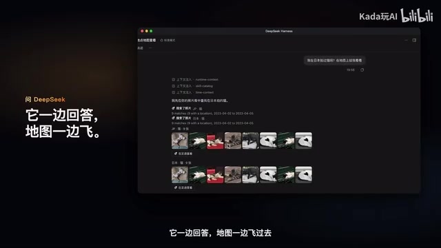
"Footprints" also does two clever things: first, "That Day in Years Past," which surfaces photos from this same day in previous years and tells you what happened in history near places you've been; second, the search experience. Searching for photos is like talking—for example, type "Kyoto 2023 cat," or directly ask DeepSeek "Have I ever photographed a cat in Japan?"

DeepSeek answers while the map flies over. This "conversation as query, result as map" interaction connects natural language understanding with geographic visualization. How many countries and cities you've visited, and how far you've traveled on the road, are all visible at a glance.
The Multimodal Retrieval Behind Natural Language Search
Being able to find the right photo by typing "Kyoto 2023 cat" involves cross-modal retrieval: breaking the user's natural language query into multiple constraints such as time, place, and object, then matching them separately against the photo's metadata and visual content. Time and place can be filtered directly from EXIF, while object or scene information like "cat" requires computer vision models to tag image content or generate vector representations to build a searchable index.
The large model plays the role of "query understanding and orchestration": it parses a colloquial question into structured conditions, determines which go to metadata filtering and which go to the visual index, and finally hands the results back to the map for rendering. This also explains why the map can "fly over while answering"—the language model handles semantics, the map component handles spatial positioning, and the two are connected through coordinates as a shared language.
Privacy and Boundaries: Read-Only, Local Indexing
Beyond features, this plugin makes clear commitments on data security: the photo library is opened read-only and never modified; the index stays only on the user's Mac. This means the image content itself is never uploaded or altered, and the location index is confined to the local device.
This is especially critical for album-type tools, because photos are among the most privacy-dense data there is. Keeping the index local and revoking modification permissions is the precondition for making people dare to use it and want to use it.
What Local Indexing and Read-Only Access Mean
"The photo library is opened read-only" means the plugin only requests read permission and does not request write or delete access, eliminating at the system level the risk of accidentally modifying or deleting original images. "The index stays only on the user's Mac" means the plugin builds the data structures needed for search and aggregation within the local device, rather than uploading photos or coordinates to a remote server for processing.
The cost of local indexing is constrained computing resources, requiring lighter-weight models and more efficient storage structures; the benefit is a clear privacy boundary—image content and location trails never leave the device, so even if a data problem occurs on the server side, it can't affect your personal album. For highly privacy-sensitive data like photos, this "capability on the edge, data stays on the edge" design is gradually becoming a baseline requirement for album-type AI tools.
Why It's Worth Paying Attention To
The value of "Footprints" isn't that it invented new technology, but that it recombines several mature capabilities—photo geolocation metadata, computer vision recognition, natural language large models, and map rendering—in a way that fits daily needs remarkably well. It advances the album from the "store it away" stage to the "walk it back" stage.
For AI application developers, this is also a signal: DeepSeek Harness, as a plugin ecosystem, is encouraging this kind of lightweight creation oriented toward personal memory and life scenarios. Rather than pursuing breadth and comprehensiveness, going deep on a single real pain point is more likely to make people feel "I need this."
One-line Summary
The "Footprints" plugin projects photo coordinates onto a nighttime Earth, turning your album into a replayable life map.
Paragraph Summary
"Footprints," a plugin based on DeepSeek Harness that appeared on Bilibili, reads the geolocation metadata embedded in photos, lights up the places where users have taken pictures on a nighttime globe, and supports zooming progressively from the globe down to streets and mountains. The plugin automatically recognizes and labels scenic spots and landmarks in photos, sorts photos by quality with burst shots and screenshots stepping aside, and organizes days of far-from-home travel into individual journeys replayed stop by stop with "Story Camera." It also offers "That Day in Years Past" historical lookbacks and natural language searches like "Kyoto 2023 cat," with the map flying to the result locations in sync with the answer. On privacy, the photo library is opened read-only and the index is kept only on the local device. The article argues its value lies in recombining mature capabilities to fit daily needs, and that it reflects the potential of the plugin ecosystem in personal memory scenarios.
Related articles

Quiver Launcher + Game List: One-Stop Management for PC Ported Games
Learn how the open-source Quiver launcher (localized) and game project list work together: the list discovers PC port and recompilation projects, while the launcher handles installation, version updates, and tag management, with full workflow and manual import options.

Lost DSH Crash Logs? This Open-Source Black Box Makes Every Crash Traceable
DSH WARN logs flash by and vanish on restart? The open-source DSH Runtime Lock black box writes WARN/ERROR to local JSONL in real time, auto-rotates to keep four segments, zero dependencies, no network requests, one-command setup.

DeepSeek Vision Lead Zhang Bo Launches Open-Source Linger: Departure After Billion-Yuan Funding and the New Agent Battle
Former DeepSeek vision-language lead Zhang Bo announces a startup after billion-yuan funding, launching open-source desktop personal agent Linger, pitting local model optimization and third-party model access against token-billed cloud services.