Geosql: A Vertical Skill Pack That Teaches AI Geospatial Data Analysis

Geosql injects geospatial SQL expertise into AI assistants for reliable PostGIS query generation.
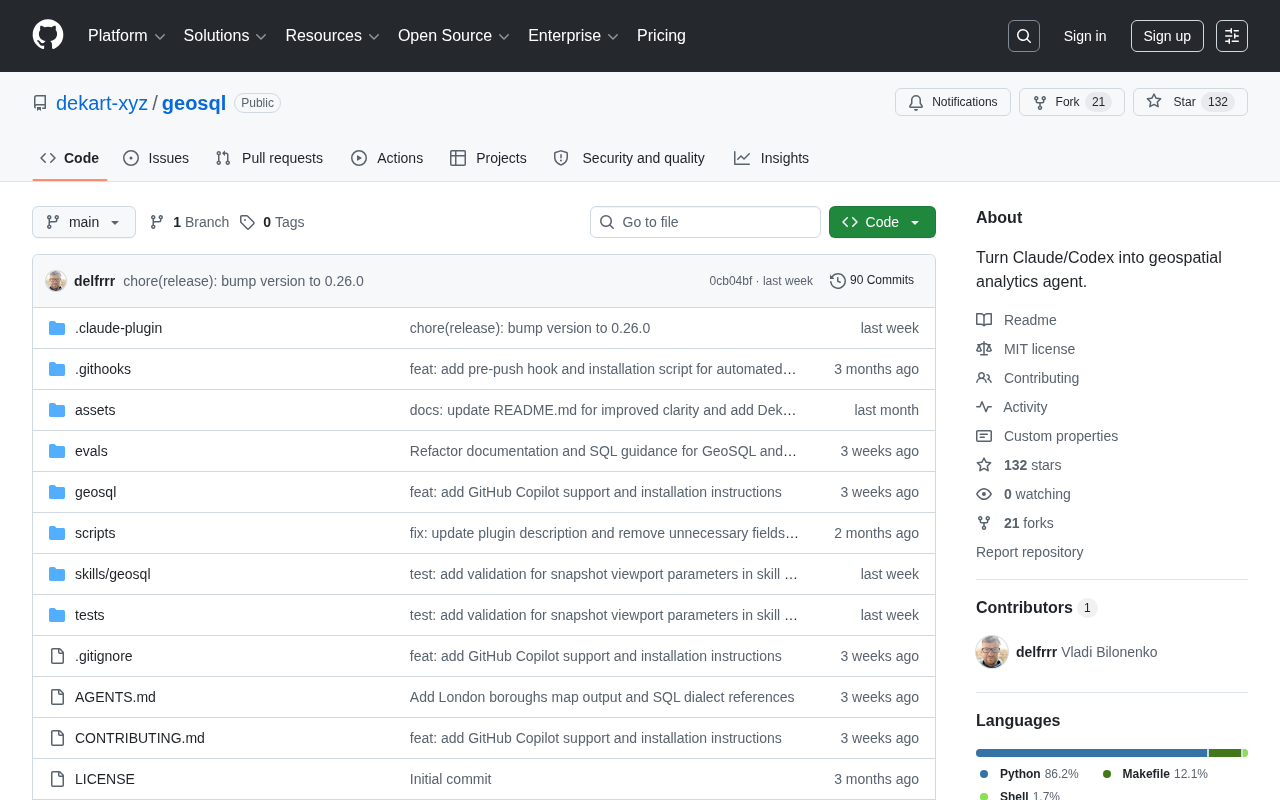
Geosql is a Skill pack for AI coding assistants like Claude and Codex, enabling LLMs to reliably generate PostGIS queries, handle coordinate transformations, and perform spatial analysis. This article explores its design logic, application scenarios, and limitations, and examines the industry trend of vertical AI skill encapsulation.
When AI Meets Geospatial Data
Geospatial Data has long been recognized as one of the toughest domains in data analysis. Whether it's urban planning, logistics optimization, environmental monitoring, or commercial site selection, working with data involving latitude/longitude, geometric shapes, and spatial relationships requires specialized toolchains and deep domain expertise.
Geospatial data involves not only coordinates and geometric shapes, but also topological relationships, spatial reference systems, multi-scale representations, and many other dimensions. To truly grasp its complexity, we need to start with the "two pillars" of the data:
The OGC standards framework has been continuously developed by the Open Geospatial Consortium since its founding in 1994, encompassing a series of open standards such as WMS (Web Map Service), WFS (Web Feature Service), and WCS (Web Coverage Service), which laid the foundation for modern GIS interoperability. OGC's core contribution lies in unifying the exchange formats, service interfaces, and geometric computation specifications of geospatial data into international standards, enabling GIS systems from different vendors and platforms to "speak the same language." The SQL/MM Spatial standard implemented by PostGIS is precisely the concrete realization of OGC specifications in the relational database domain.
The EPSG coordinate reference system database (from the European Petroleum Survey Group) solves another core problem: throughout history, surveying activities in different regions and for different purposes have given rise to thousands of coordinate reference systems (CRS) that are mutually incompatible. The EPSG database catalogs over 6,000 coordinate reference systems, each identified by a unique integer ID: the globally common WGS84 corresponds to EPSG:4326, the Web Mercator widely used in internet maps corresponds to EPSG:3857, and China's national geodetic coordinate system CGCS2000 corresponds to EPSG:4490. This EPSG coding system is the common language for GIS engineers in daily communication, and also the core indexing basis when PostGIS performs ST_Transform coordinate transformations.
The global spatial data market is projected to exceed $90 billion by 2027, yet the supply of professional GIS talent has always been an industry bottleneck—engineers who master the complete GIS technology stack typically need years of cross-disciplinary accumulation in surveying, databases, and programming. This supply-demand gap is precisely the fundamental driver behind AI-assisted tools entering the geospatial domain.
Traditionally, analysts needed to be proficient with tools like PostGIS, GDAL, and QGIS, and deeply understand complex concepts such as projected coordinate systems, spatial indexing, and topological relationships. Each of these tools plays a different role: PostGIS is the spatial extension for PostgreSQL, implementing the OGC-defined SQL/MM Spatial standard and supporting the storage and computation of geometric types like points, lines, and polygons; GDAL, on the other hand, is a low-level library for handling raster and vector geographic data formats, and is invoked by nearly all GIS software.
Worth mentioning is that cloud-native geospatial formats are reshaping data storage and access patterns. GeoParquet, a columnar storage format based on Apache Parquet, achieves efficient compression and predicate pushdown for large-scale spatial data by embedding WKB (Well-Known Binary) geometry encoding and CRS metadata within Parquet files. Compared to traditional Shapefiles, GeoParquet not only eliminates the limit on the number of attribute columns but also natively supports random access on cloud storage (such as S3), enabling modern analytical engines like DuckDB and BigQuery to execute spatial queries directly on object storage without loading data into dedicated GIS servers. The maturation of this ecosystem is driving Skill tools to expand from a single PostGIS dialect to a broader range of spatial analysis engines.
Particularly thorny is the problem of projected coordinate systems: the Earth is an ellipsoid, and projecting it onto a two-dimensional plane inevitably produces distortion. Different regions adopt different projection schemes (such as GCJ-02 and WGS84 commonly used in China, and UTM projections commonly used in engineering). Behind coordinate system selection lies deep geodetic expertise—each projection makes trade-offs among four properties: area, shape, distance, and direction. Conformal projections (like Mercator) preserve local shape but severely distort area; equal-area projections (like Albers) preserve area but distort shape; equidistant projections preserve distance in specific directions. Mismatched coordinate systems can lead to distance calculation errors of tens of meters or even kilometers, while misunderstanding projection principles can cause systematic analytical errors.
The Geosql project, which recently appeared on Hacker News, attempts a new approach to lowering this barrier—it is a "Skill" designed specifically for AI coding assistants like Claude and Codex, enabling large language models to more reliably understand and generate geospatial SQL queries.
What Is an AI Skill
The Core Concept of a Skill
As AI coding assistants like Anthropic's Claude and OpenAI's Codex continue to improve, the community has begun exploring how to inject domain-specific expertise into these models. A so-called "Skill" is essentially a structured set of domain knowledge, prompt templates, and tool invocation specifications, enabling a general-purpose large model to perform like a domain expert on specific tasks.
To understand how Skills work, we first need to understand the protocol foundation behind them. The Model Context Protocol (MCP) is an open protocol released by Anthropic in 2024, designed to standardize the interface specifications between AI models and external tools and data sources. MCP's architectural design is heavily influenced by the Language Server Protocol (LSP)—the latter being a protocol designed by Microsoft for VS Code to decouple editors from language services, which has become the de facto standard in the IDE ecosystem. LSP's core insight is that editors and language intelligence services should be decoupled, communicating through a standardized protocol rather than developing a separate plugin for each language in each editor. MCP brings the same idea to the AI tool ecosystem: AI models don't need to hard-code interaction logic for each external tool, but instead dynamically discover and invoke tool capabilities through the unified MCP protocol.
MCP also adopts a Client-Server architecture, communicating via JSON-RPC 2.0, supporting both stdio and HTTP+SSE transport methods, and exposing three categories of capabilities to the model: Tools (callable functions), Resources (readable data sources), and Prompts (predefined prompt templates). Within this framework, a Skill can be understood as an MCP Server encapsulating domain knowledge. It not only provides function invocation interfaces but also includes structured contextual prompts (domain specifications in the System Prompt), example query templates (Few-shot Examples), and runtime validation logic.
Unlike RAG (Retrieval-Augmented Generation), a Skill places more emphasis on encapsulating procedural knowledge for specific tasks, rather than document retrieval. RAG excels at finding relevant information fragments within vast collections of documents, making it suitable for dynamic retrieval of factual knowledge; whereas a Skill encapsulates the methodology of "how to correctly complete a certain type of task"—akin to an expert's operating manual rather than an encyclopedia. In practice, the two often need to be combined: RAG handles retrieving the latest function documentation and examples, while the Skill ensures the generation process follows the correct reasoning framework.
From a cognitive science perspective, large language models face unique challenges when handling geospatial tasks. An LLM's core capabilities derive from learning statistical patterns within text sequences, whereas spatial relationships are essentially multidimensional geometric structures that are difficult to fully linearize into textual expression. Research shows that current mainstream LLMs have far lower accuracy in Euclidean spatial reasoning (such as determining whether two line segments intersect) than their performance on textual reasoning tasks. This is not a problem of insufficient training data, but an inherent limitation of the autoregressive language model architecture—it is more adept at pattern matching and knowledge retrieval than at genuine geometric deductive reasoning. Part of the value of Skill encapsulation lies precisely here: through predefined function templates and validation logic, it transforms judgments requiring geometric intuition into deterministic rule-based paths, bypassing the model's reasoning weaknesses.
This is especially critical for geospatial data. PostGIS provides hundreds of spatial functions, and their correct use requires deep knowledge of geometry and databases. Although large models can write syntactically correct SQL, they often fail to accurately grasp spatial database–specific functions (such as ST_Intersects, ST_Distance, ST_Buffer, etc.) and are prone to errors in details like coordinate system transformations and unit conversions.
Take ST_DWithin as an example: it determines whether two geometric objects are within a specified distance, but its precision depends entirely on the coordinate system used by the geometric data—if a geographic coordinate system (latitude/longitude) is used, the unit is degrees rather than meters, requiring ST_Transform to first convert to a projected coordinate system, or using the geographic version of ST_DWithin with the use_spheroid parameter.
The differences between ST_Intersects and functions like ST_Contains, ST_Within, and ST_Overlaps are rooted in the underlying theoretical framework of DE-9IM (Dimensionally Extended 9-Intersection Model). This model, proposed by Egenhofer and Herring in 1991, precisely describes the spatial topological relationship between any two geometries using a 3×3 matrix by examining the nine pairwise intersections between the Interior, Boundary, and Exterior of the two geometries. Take "a point lying on the boundary of a polygon" as an example: in this case ST_Within returns false (the point is not inside the polygon's interior), ST_Intersects returns true (the point intersects the polygon), and ST_Contains returns false (the polygon does not fully contain the point's interior)—the three functions give different results for the same scenario, fully consistent with the rigorous mathematical definition of DE-9IM, yet extremely confusing to users unfamiliar with the underlying model. This is precisely the kind of scenario where AI-generated queries are prone to errors.
To assess whether AI-generated spatial SQL is reliable, the industry has gradually formed a checklist across several dimensions: semantic correctness (whether function selection matches business semantics), coordinate system consistency (whether input and output CRS match, and whether units are degrees or meters), index accessibility (whether the query formulation can trigger spatial index acceleration), and boundary condition handling (special geometric behavior with empty geometries/NULL, crossing the 180° antimeridian, and near the poles). One of the core values of Skill tools like Geosql is precisely to structurally inject these checklists into the model's reasoning process, enabling it to proactively avoid the above pitfalls when generating queries. Geosql's positioning is exactly to fill this gap.
Geosql's Design Goals
As a targeted skill pack, Geosql's core goal is to enable AI assistants to:
- Accurately generate SQL queries for PostGIS and other spatial databases
- Correctly handle spatial relationship determination and geometric operations
- Understand coordinate reference systems (CRS) and projection transformation logic
- Optimize spatial query performance and reasonably leverage spatial indexes
By encapsulating this expertise into reusable skill modules, even ordinary users unfamiliar with GIS can, with AI's help, complete relatively complex spatial data analysis tasks.
Why This Direction Is Worth Watching
Dramatically Lowering the Professional Barrier
Geospatial analysis has long been a high-barrier niche field. Consider a typical scenario: "Find all coffee shops within 500 meters of any subway station, and count them by administrative district." It's intuitive and clear to describe in natural language, but translating it into correct spatial SQL requires considerable professional expertise—not only choosing the right functions, but also handling coordinate system consistency, spatial index utilization, geometry validity verification, and a whole series of engineering details.
This seemingly simple query actually involves multiple layers of professional judgment: first, it needs to confirm that the subway station and coffee shop data use the same CRS; second, it needs to choose ST_DWithin rather than ST_Distance (the latter cannot leverage spatial indexes); it also needs to decide whether to approximate calculations using degrees in the geographic coordinate system, or first convert to a local projected coordinate system for precise calculation in meters; finally, it must ensure a GiST index exists on the geometry column, otherwise query performance will degrade sharply when facing millions of data points.
In actual GIS engineering, data quality issues are often another major cause of analysis failure, yet this dimension is frequently overlooked in discussions of AI-generated queries. In real-world spatial datasets, geometry validity problems are extremely common: self-intersecting polygons, unclosed rings, duplicate vertices, degenerate geometries with zero area—these are collectively known as "Invalid Geometry." PostGIS provides the ST_IsValid detection function and the ST_MakeValid repair function, but the repair strategy itself requires domain judgment: should a self-intersecting polygon be split into multiple valid sub-polygons, or should the overlapping region be deleted, or should the feature simply be discarded? Different repair strategies produce dramatically different analytical results. Furthermore, gaps and overlaps caused by acquisition precision are especially thorny in scenarios like land tenure analysis and administrative boundary merging, often requiring ST_SnapToGrid or topological repair workflows (such as the PostGIS Topology extension). AI-generated queries typically assume the input data is clean, which creates a significant gap with the realities of production environments, and is also a scenario that Skill tools need to explicitly cover in their validation logic.
The value of tools like Geosql lies in "attaching" domain knowledge to large models, making the conversion from natural language to professional spatial queries more reliable. This aligns closely with the current direction of the entire AI programming ecosystem—moving from general-purpose code generation toward deep optimization for vertical domains.
Industry Signals of Skill-Based Encapsulation
The emergence of such projects on Hacker News reflects a larger trend: the expansion of AI assistant capabilities is shifting from "making the model itself stronger" to "making the ecosystem tools stronger." This evolution has clear technical logic:
In the early stage, model capabilities depended entirely on the density of knowledge in the training data, with uneven performance across niche domains; after 2023, Function Calling, plugin systems, and RAG pipelines matured one after another, enabling models to dynamically acquire external knowledge during inference; and the wave of protocol standardization represented by MCP further drove the formation of a "skill marketplace"—developers can write, distribute, and combine various professional skill packs for models, similar to the App Store model of the mobile app ecosystem.
This trend is evolving in parallel across multiple vertical industries, and presents three distinct technical paths: the fine-tuning path is represented by Bloomberg's BloombergGPT released in 2023, which continues training on large amounts of financial corpora to internalize the language patterns and reasoning frameworks of the financial domain, suitable for scenarios where the knowledge system is relatively stable and high demands are placed on the model's intrinsic capabilities; the RAG path is represented by the biomedical toolchain continuously maintained by the BioNLP community, which dynamically retrieves the latest literature and databases, suitable for scenarios where knowledge is frequently updated and precise source citations are needed; the Skill encapsulation path is represented by Harvey AI's injection of legal reasoning frameworks, suitable for scenarios that are procedural-knowledge-intensive, where the cost of errors is extremely high but the knowledge structure is relatively fixed.
The Skill encapsulation path that Geosql represents has the advantages of zero training cost and flexible knowledge updates compared to fine-tuning, while placing more emphasis on procedural knowledge (how to correctly use a certain function) rather than the retrieval of factual knowledge compared to RAG. In practice, the three paths often need to be combined, and together they reveal a pattern: in domains where knowledge is highly specialized and the cost of errors is extremely high, relying solely on the "generalization ability" of general-purpose large models is often insufficiently reliable, and domain best practices must be made explicit through appropriate mechanisms.
Developers have gradually realized that rather than waiting for foundation models to become perfect in every niche domain, it is better to explicitly inject domain-specific best practices into the model through mechanisms such as Skills, plugins, and MCP. For highly specialized domains like geospatial, this modular path is more practical than waiting for foundation models to naturally acquire all the details, and it is also easier to maintain the timeliness and accuracy of knowledge. This modular, composable approach is becoming the mainstream paradigm for building practical AI applications. Geospatial is just one of many vertical domains, and similar skill packs oriented toward directions like financial analysis, bioinformatics, legal compliance, and healthcare are likely to continue emerging in the future.
Practical Value and Limitations
Potential Application Scenarios
Combined with AI coding assistants, Geosql can empower various practical business scenarios:
- Urban and transportation planning: Quickly analyzing facility coverage and regional accessibility
- Business intelligence: Store site selection, trade area analysis, and competitor spatial distribution
- Environmental and agricultural monitoring: Tracking land use changes and analyzing regional climate data
- Logistics and delivery optimization: Service area division and route efficiency evaluation
For small and medium-sized teams, this means being able to conduct basic spatial data analysis without a dedicated GIS engineer, significantly reducing labor and time costs.
Limitations That Require a Rational View
It's worth noting that Geosql is still an early-stage community project, and its maturity and applicability need further validation. Although AI-generated spatial queries can greatly improve efficiency, in production environments, analytical results involving critical decisions still need to be reviewed by professionals.
The inherent complexity of spatial data—mixed coordinate systems, data precision deviations, performance bottlenecks in large-scale geometric operations—cannot be fully resolved by a single skill pack. Take performance as an example: PostGIS uses an R-Tree spatial index (implemented through PostgreSQL's GiST—Generalized Search Tree framework) to accelerate spatial queries. The R-Tree was proposed by Guttman in 1984; its principle is to use hierarchical minimum bounding rectangles (MBR, Minimum Bounding Rectangle) to approximately represent geometric objects, thereby transforming the spatial search problem into rectangle intersection determination, greatly narrowing the candidate set.
The performance advantage of the R-Tree index comes from its hierarchical organization: each non-leaf node stores the MBR of its child nodes, and queries prune top-down from the root node, with only subtrees whose MBR intersects the query range continuing to be searched. For uniformly distributed geometric data, the R-Tree can reduce search complexity from O(n) to O(log n); but when data distribution is extremely uneven (such as dense urban building areas coexisting with sparse rural areas), index efficiency declines somewhat, requiring the use of data partitioning strategies.
At the actual execution level, PostGIS uses a Two-Pass Filter mechanism: the first stage completes coarse filtering (Filter Step) through the R-Tree index, quickly excluding a large number of irrelevant geometric objects based solely on MBR intersection; the second stage performs precise geometric topological operations (Refinement Step) on the candidate set. ST_Intersects works exactly this way internally—first using the && operator to trigger index acceleration, then precisely determining the DE-9IM relationship between two geometries.
The key point is that the spatial index is only activated when the query condition correctly triggers the && operator (MBR intersection). If an AI-generated query is poorly formulated—for example, applying a function transformation to the geometry column in the WHERE clause (such as ST_Transform(geom, 4326) && ... rather than transforming first and then building the index), or using function combinations that don't support index acceleration—operations on millions of geometry records may degrade into full table scans, with execution time exploding from milliseconds to several minutes. This type of performance tuning still relies on experienced engineers to intervene, and is also the most easily overlooked hidden risk when evaluating AI-generated queries.
Furthermore, with the proliferation of GPS devices and IoT sensors, Spatiotemporal Data is becoming a new frontier challenge. MobilityDB is PostGIS's temporal extension, introducing the "Moving Geometry" data type, which can represent points that change continuously over time (such as vehicle trajectories) and regions (such as typhoon impact ranges). For Skill tools, spatiotemporal scenarios introduce additional complexity: beyond spatial predicates, they must also correctly handle time interval operations, trajectory interpolation method selection, and the trigger conditions for spatiotemporal indexes (such as the STR-Tree). This is an expansion direction that current tools like Geosql have not yet fully covered but which holds significant practical value, and it also indicates that the evolutionary space for AI geospatial skill packs is far from reaching its ceiling.
A more accurate positioning for such tools would be as "efficiency multipliers for professionals," rather than an all-purpose solution that "comprehensively replaces domain expertise."
Conclusion
Geosql represents a slice of the AI tool ecosystem's evolution worth watching: by injecting vertical domain skills into large models, it makes once-high-barrier professional capabilities within reach. Although it is currently still a niche, early-stage project, the core idea behind it—skill-based encapsulation of domain knowledge—is likely to be one of the important paths for AI applications to truly take root across various industries.
From OGC standards to EPSG coordinate systems, from the DE-9IM topological model to R-Tree spatial indexes, from the GeoParquet cloud-native format to the MobilityDB spatiotemporal extension, the professional knowledge systems accumulated over decades in the geospatial domain are being reorganized and transmitted by AI tools in a new way. This process is not replacement, but a re-encapsulation of knowledge—enabling the domain wisdom accumulated by a few experts to benefit a broader range of users at a lower barrier.
For developers interested in the intersection of AI programming and geospatial data analysis, such projects are worth continuous tracking. They are not just tools themselves, but also a window for observing how AI is gradually penetrating various professional domains.
Key Takeaways
- The complexity of geospatial data is rooted in the overlapping of multiple layers of professional knowledge, including the OGC standards framework, the EPSG coordinate system, and the DE-9IM topological model
- Large language models have inherent architectural limitations in geometric spatial reasoning; Skill encapsulation bypasses the model's reasoning weaknesses through rule-based paths
- Skill encapsulation is a third path between model fine-tuning and RAG, focusing on the structured injection of procedural knowledge
- The MCP protocol, through standardized tool invocation interfaces, provides the infrastructure for the formation of a "skill marketplace" ecosystem
- PostGIS's two-pass filter mechanism makes spatial index utilization the key to performance optimization, and this is precisely where AI-generated queries are most prone to hidden risks
- Real-world spatial data commonly has invalid geometry problems; AI-generated queries typically assume clean data, creating a gap with the realities of production environments
- Cloud-native formats like GeoParquet and spatiotemporal extensions like MobilityDB represent new frontiers that Skill tools need to continuously keep up with
- The essence of skill-based encapsulation of domain knowledge is to bring the procedural knowledge accumulated by experts to a broader range of users at a lower barrier
Related articles

Insufficient Source Material: A Tweet With No Substantive Content
A single tweet reading 'Available until the goblins notice.' with two unexpanded links provides no substantive content to write an article from.
Google Jules AI Coding Assistant: A Quick Look at an Open-Source Practice Repo
A look at a small GitHub repo centered on Google Jules, an autonomous AI coding agent. Explores what Jules does, the repo's practical value, and how to evaluate early-stage AI tool projects.
GitHub Project Overview: prateek0221/jules — Critically Lacking Information
The GitHub repo prateek0221/jules has only 1 star, no code, and no README. We review available info and provide background on Google's Jules AI coding agent.