The Mystery of America's Easternmost and Westernmost Points: Two Answers Depending on How You Define Direction

America's easternmost and westernmost points have two valid answers, depending on whether you use longitude or navigational direction.
The question of where the US begins and ends — east to west — has two entirely valid but contradictory answers. By longitude, Alaska's islands straddling the anti-meridian make it simultaneously the northernmost, westernmost, and easternmost state. By navigational direction, the westernmost point is Guam's coast and the easternmost is St. Croix in the US Virgin Islands. Remarkably, both navigational extremes are called Point Udall, named after brothers Stewart and Mo Udall, making Americans the "warm filling in a Udall sandwich." The deeper insight: geographic "facts" are often built on human-made frameworks.
East and West Are Human Inventions
North and south are easy to define — the Earth's rotational axis runs straight through the poles, making it obvious which way is up and which is down. East and west are a different story. There's no natural reference point, so humans had to draw an arbitrary line: the prime meridian.
For a long time, that line ran through Greenwich. Under the longitude system, the farther you are from the prime meridian, the farther east or west you are. On the opposite side of the Earth, that line corresponds to the anti-meridian. From a longitude standpoint, the anti-meridian is simultaneously the most eastern and most western point on the planet — a seemingly contradictory fact that lies at the heart of this whole puzzle.
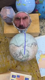
The selection of the prime meridian itself has a fascinating and contentious history. Before the late 19th century, each country used its own standard — France used the Paris meridian, Britain used Greenwich, Spain and the Netherlands had their own references, causing enormous confusion for navigation and cartography. In 1884, the International Meridian Conference in Washington convened 25 nations and voted to establish Greenwich as the global prime meridian (0° longitude), largely because British Royal Navy charts were already in widespread use and the Greenwich Observatory had accumulated extensive, precise navigational data. France abstained, and continued using the Paris meridian on domestic maps for decades. This "origin point of global coordinates" came not from any physical feature of the Earth, but from a political and pragmatic compromise — an important backdrop for understanding the inherently arbitrary nature of the anti-meridian discussed below.
By Longitude: Alaska Claims North, West, and East
If you strictly follow the longitude system, the westernmost point of the United States is the piece of land in the Western Hemisphere that comes closest to the anti-meridian without actually crossing it. That point is Amatignak Island in Alaska, just 37 miles from the "edge of the west."
This answer feels a bit awkward, though. If you keep heading west from Amatignak Island, you'll encounter more U.S. territory — so how can it be the "westernmost" point? The answer: to reach those islands farther west, you must cross the anti-meridian. Once you do, those islands become "extremely eastern" in terms of longitude.
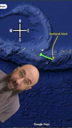
The first piece of U.S. territory you encounter after crossing that line is Semisopochnoi Island, also in Alaska. By longitude, it contains the easternmost point in the United States. This leads to a striking conclusion: under this system, Alaska is simultaneously the northernmost, westernmost, and easternmost point in the country.
The anti-meridian (180° longitude) isn't perfectly straight in practice — it roughly follows the International Date Line. To avoid splitting countries or island groups across different calendar days, the Date Line zigzags around Kiribati, Fiji, and other Pacific archipelagos. The Aleutian Islands sit right along this line, with Alaska's western island chain straddling 180° on maps, which is why some islands "jump" to the Eastern Hemisphere in terms of longitude. This geographic reality vividly illustrates the internal contradiction of using the longitude system to describe "easternmost" and "westernmost": an artificially bent line determines whether a piece of land is defined as "most eastern" or "most western."
By Navigation: A Completely Different Answer
There's another way to define east and west — by navigational direction. This approach sets aside the coordinate grid entirely and focuses on how we actually get to a place.
The question it asks is: within U.S. territory, where can you stand such that heading any further west takes you out of the country? That's the westernmost point. By this standard, the westernmost point of the United States is the western coast of Guam. Even though Guam sits quite far east by longitude, the most direct route to it from anywhere else in the U.S. is to travel west.
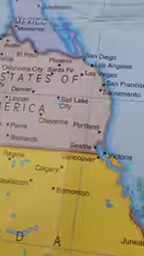
The same logic tells us that the easternmost point of the United States is the eastern coast of St. Croix in the U.S. Virgin Islands — because heading east from anywhere else in the country is the most direct way to get there.
The "Udall Sandwich": America Embraced by Two Brothers
These two navigational extremes also happen to share a remarkable naming coincidence.
The easternmost point of St. Croix is called Point Udall, named after Stewart Udall, who served as Secretary of the Interior under Presidents Kennedy and Johnson. He devoted himself to protecting vast swaths of America's natural landscape, including Buck Island Reef in the U.S. Virgin Islands.
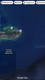
Years later, the westernmost point of Guam was also officially named Point Udall — this time to honor Stewart's brother, Mo Udall. So by navigational reckoning, America begins at Point Udall and ends at Point Udall. One Udall brother stands to the east, the other to the west, their arms wrapped around the entire country. As one commentator put it, Americans are the "warm filling in a Udall sandwich."
Why "Easternmost" and "Westernmost" Have No Single Correct Answer
The reason this seemingly simple geographic question yields two completely different answers comes down to this: "east" and "west" are not objective physical directions. They are concepts built on human convention.
The longitude system depends on the prime meridian — an arbitrarily chosen line — which creates the circular paradox of the anti-meridian, where "most eastern" and "most western" collapse into the same point. The navigational definition sidesteps coordinates altogether and returns to the lived human experience of moving through space. Neither approach is wrong; they simply apply different frameworks to the same question.
This is a reminder that many seemingly objective "geographic facts" have human-made definitions quietly embedded within them. Change the frame of reference, and the answer can change entirely.
Background Notes
Stewart Udall (1920–2010) served as Secretary of the Interior under Presidents Kennedy and Johnson from 1961 to 1969, presiding over a golden era of American environmental legislation. The Wilderness Act, the forerunner to the Endangered Species Act (the Endangered Species Preservation Act of 1966), and the National Trails System Act were all passed or laid the groundwork during his tenure. His younger brother Mo Udall (1922–1998) served as a U.S. Representative from Arizona and was equally known for championing environmental protection and public lands conservation; he ran in the 1976 Democratic presidential primary. The two Point Udalls were named in different years, yet together form a symmetrical naming coincidence that reflects the lasting influence of one political family on America's public land heritage in the latter half of the 20th century.
Related articles

Workbuddy for Absolute Beginners: How a Desktop AI Agent Fits Into Real Workflows
A beginner's guide to the Workbuddy desktop AI agent: installation, claiming credits, file management, and building automated workflows—compared with CodeX for fit and cost, helping professionals shift from AI question-askers to AI managers.

OpenAI's New Agent Stack: Computer Use, Decisions API, and Ultra-Fast Workflows
OpenAI Dev Day unveiled a new agent stack: Computer Use outperforms humans, Decisions API delivers ultra-low-latency classification via Luna, Agents API opens the same Computer Use capabilities, and GPT-6.1 Sol costs only one-seventh of Astra. Core updates, benchmark data, and developer insights.

Liang Wenfeng Open-Sources DeepInfo Inference Framework, Takes On U.S. Ban
DeepSeek open-sources its DeepInfo inference framework after its models, featuring GPU/CPU cross-pipelining, small-model prediction with large-model verification, and full Huawei Ascend and NVIDIA chip support—facing the U.S. federal ban head-on. This article analyzes its significance for AI deployment and open-source strategy.