Unfenced: Using Map Data to Precisely Filter Properties for Sale Adjacent to Public Land

Unfenced scans 700K U.S. listings weekly to precisely find properties bordering public land.
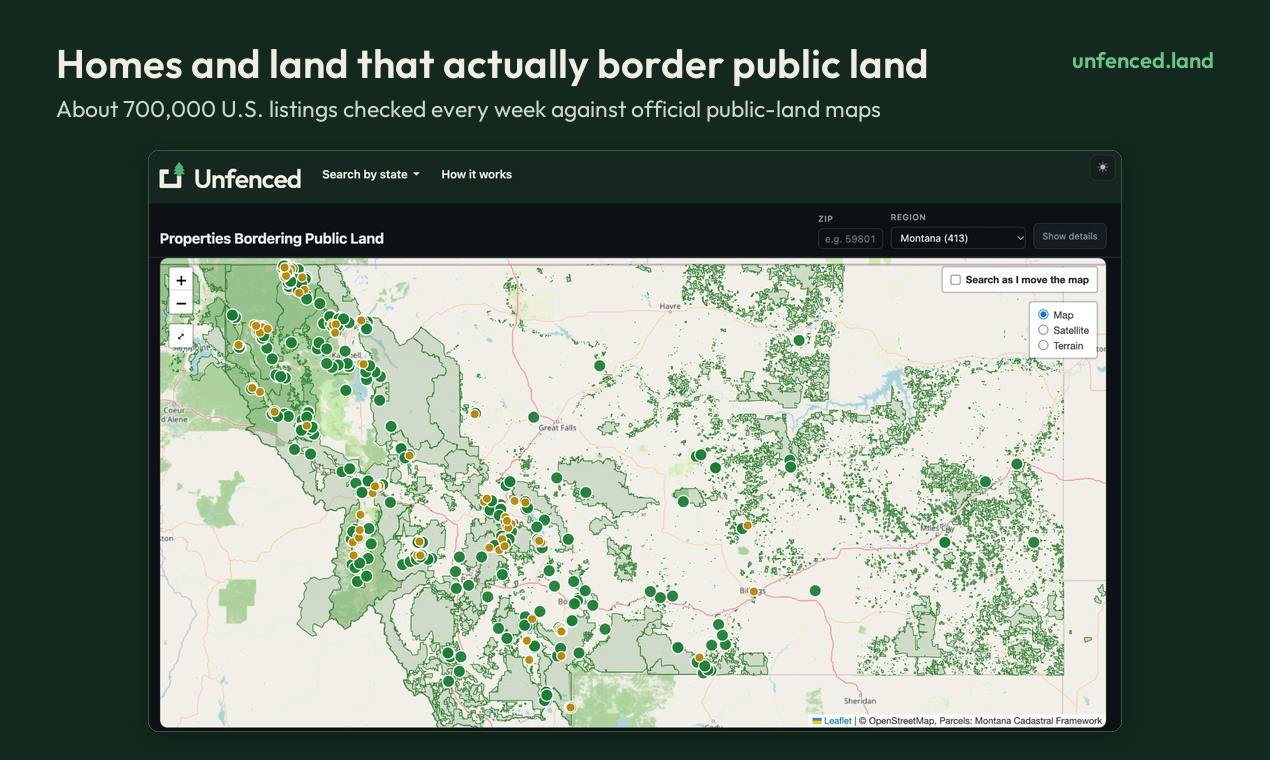
Unfenced is a free, no-registration property search tool that scans ~700K U.S. listings weekly, comparing them against official public land maps to find ~13,600 properties bordering national forests, BLM, and state land. It precisely measures shared boundary length based on county parcel data, visualizes it on a map, and adds elevation, road access, flood, and wildfire insights—automating what once required multiple government database lookups.
When buying land or property, whether it borders public land is a key factor affecting privacy, recreational opportunities, and long-term value. But traditional real estate platforms rarely provide this dimension of information, and buyers often have to manually compare parcel boundaries with public land maps—time-consuming, laborious, and error-prone. Unfenced, a new product on Product Hunt, aims to solve this problem: it checks about 700,000 U.S. property listings every week and compares them against official public land maps to filter out listings that genuinely border national forests, Bureau of Land Management (BLM) land, and state land.
Precisely Filtering from Massive Listings
The core logic of Unfenced isn't complicated, but executing it requires a lot of data work. Every week it scans about 700,000 U.S. property listings, performs spatial comparison against official public land maps, and ultimately identifies about 13,600 homes and parcels that truly border public land.
"Bordering" here is not vague proximity but precise measurement based on county parcel boundaries. For each qualifying listing, Unfenced calculates the length of the shared boundary (in feet) and draws it on a map. This means buyers can see exactly which segment of their parcel overlaps with public land and how long that boundary is, rather than merely knowing that "public land is nearby."
This precision matters greatly for land purchase decisions. A 50-foot shared boundary and a 500-foot shared boundary deliver completely different user experiences and potential value.
County parcel boundary is parcel subdivision data maintained by U.S. local governments for tax and property rights management, with each parcel having a unique Assessor's Parcel Number (APN). Such data is maintained by county assessor offices or Geographic Information System (GIS) departments, with widely varying formats and precision: some counties provide high-precision vector polygons, while others have only scanned maps or low-precision line maps. National datasets (such as Regrid, ReportAll) unify formats by integrating county data, but update frequency and coverage completeness still depend on the source. Unfenced's shared boundary measurement is based on this type of data, so its accuracy ceiling is constrained by the quality of county parcel data.
Beyond Boundaries: Multi-Dimensional Parcel Information
In addition to shared boundary length, Unfenced provides several supplementary data points for each listing to help buyers more comprehensively assess parcel conditions:
- Public land area: How much area lies behind the bordering public land, which relates to available recreational space and privacy buffer.
- Elevation: Affects climate, views, and development difficulty.
- Road access: Whether there is legal road access, a key prerequisite for land development.
- Flood risk zone: Assessment based on official flood maps, affecting insurance and construction safety.
- Wildfire hazard level: Especially important for woodland and mountain parcels.
This information typically requires buyers to query multiple government databases separately; Unfenced integrates them into a single view, lowering the barrier to information gathering.
Bureau of Land Management (BLM) is an agency under the U.S. Department of the Interior that manages about 245 million acres of public land, roughly one-tenth of U.S. land area, mainly in western states. Unlike national forests and national parks, BLM land is managed for multiple uses including grazing, mineral development, energy production, and outdoor recreation. For property buyers, bordering BLM land usually means a larger privacy buffer and potential recreational access opportunities, but may also bring adjacent-right issues such as grazing rights and mineral rights. BLM maintains a nationwide land ownership map (Surface Management Agency data), one of Unfenced's core data sources for comparing public land boundaries.
A Free, No-Account Lightweight Experience
Unfenced is quite lightweight to use: users can search by ZIP code or state, no account registration is required, and it's completely free. This lowers the cost of trying it and aligns with current consumer expectations for "use-and-go" utility products.
According to its Product Hunt page, the product received 75 upvotes, ranked 11th for the day, and has 8 comments. It is categorized under Home, Maps, and Outdoors, which closely matches its target users—buyers looking for rural property, recreational land, or land for building their own homes.
Data-Driven Land Purchase Decisions
The value of Unfenced lies in turning previously scattered, specialized data into actionable insights. For ordinary buyers, determining whether a parcel borders public land usually requires consulting parcel maps at the county recorder's office, comparing BLM or Forest Service land ownership maps, or even hiring a surveyor. Unfenced automates this process and presents the results visually.
However, the accuracy of such tools depends heavily on the completeness and update frequency of underlying data. County parcel boundary data is unevenly standardized across U.S. states and even counties, and public land map precision also varies. Unfenced claims to update listings weekly, but parcel boundary and public land data may have longer update cycles. Before making a purchase decision, buyers should still verify key information through official channels or professionals.
Additionally, the 13,600 bordering listings represent only about 2% of the 700,000 total listings—a ratio showing that properties genuinely qualifying as "adjacent to public land" are scarce, and explaining why such a filtering tool has practical value: manually finding that 2% from a list of 700,000 is nearly impossible.
Flood risk zone in the U.S. usually refers to the Special Flood Hazard Area (SFHA) designated by the Federal Emergency Management Agency (FEMA), i.e., the 100-year floodplain. Properties in this zone with federally backed loans are typically required to carry flood insurance, and building codes are stricter. Wildfire hazard level mostly comes from state forestry departments or federal wildfire risk datasets (such as the USDA Forest Service's Wildfire Hazard Potential), combining factors like fuel type, slope, climate, and fire history. Both types of information are especially critical for rural parcels: flood zones affect insurance costs and construction feasibility, while wildfire levels relate to insurance availability and fire-resistance requirements for building materials.
Who Is It For?
Unfenced is best suited for:
- Buyers seeking land for outdoor recreation such as hunting, fishing, and hiking;
- Rural property buyers hoping to purchase land bordering national forests or BLM land for extra privacy and expansion space;
- Users interested in building their own homes or off-grid living who need to assess parcel conditions (roads, flooding, wildfire);
- Real estate agents who need to quickly filter listings matching specific needs.
For urban property buyers, this tool has limited relevance, but for the rural and recreational property niche, it fills a clear information gap.
Conclusion
By integrating public land maps with property listing data, Unfenced provides land buyers with an information dimension that was previously hard to obtain: precise shared boundary measurement. Its free, no-registration model lowers the barrier to use, and its multi-dimensional parcel information improves decision-making efficiency. Of course, data accuracy and coverage remain areas to watch, and buyers should not rely entirely on a single tool for final decisions. For users focused on rural real estate and outdoor lifestyles, this is undoubtedly a starting point worth trying.
One-line Summary
Unfenced scans 700,000 U.S. property listings weekly to precisely filter properties bordering public land.
Paragraph Summary
Unfenced is a free, no-registration property search tool that scans about 700,000 U.S. property listings weekly and performs spatial comparison against official public land maps to filter out roughly 13,600 listings that genuinely border national forests, BLM land, and state land. It precisely measures shared boundary length (in feet) based on county parcel boundaries and visualizes it on a map, while providing multi-dimensional information such as public land area, elevation, road access, flood risk, and wildfire hazard level. The tool automates the tedious work of consulting multiple government databases and suits buyers of rural property, recreational land, and self-built homes, though data accuracy depends on the standardization of county parcel data.
Related articles

Chain of Thought Isn't Just for AI: How Humans Can Use CoT to Improve Thinking Quality
Chain of Thought isn't just a prompt trick for large models. Starting from a Hacker News discussion, this article analyzes why CoT works for human thinking too, breaks down actionable ways to transfer it, and highlights the key differences between human CoT and machine CoT.
Cloudflare Teams Up with OpenAI: Closi…
Cloudflare Teams Up with OpenAI: Closing the Loop from Vulnerability Discovery to Defense with AI
Cloudflare uses OpenAI Daybreak to investigate security vulnerabilities and generate reviewable remediation plans, while developers use Codex to boost coding efficiency and quality.

Orca Multi-Agent Orchestration in Practice: A Guide to Parallel Collaboration with Claude and Codex
Orca is Stable AI's free open-source agent workbench supporting 34 agents like Claude Code and Codex in parallel. Learn its Git worktree isolation, multi-model orchestration, and mobile management.