LooGo: An Ad-Free Public Restroom Finder App Based on OpenStreetMap

LooGo uses OpenStreetMap data to help Android and Wear OS users quickly find nearby public restrooms.
LooGo is an Android app that debuted on Product Hunt, aiming to ease the anxiety of finding public restrooms in unfamiliar cities. Based on OpenStreetMap data, it displays nearby restroom locations, access codes, prices, opening hours, and accessibility features on a map, supports offline maps, and natively supports Wear OS. It promises no ads and no tracking, but its business model is unclear, and its experience depends heavily on OSM data coverage—plus it's Android-only.
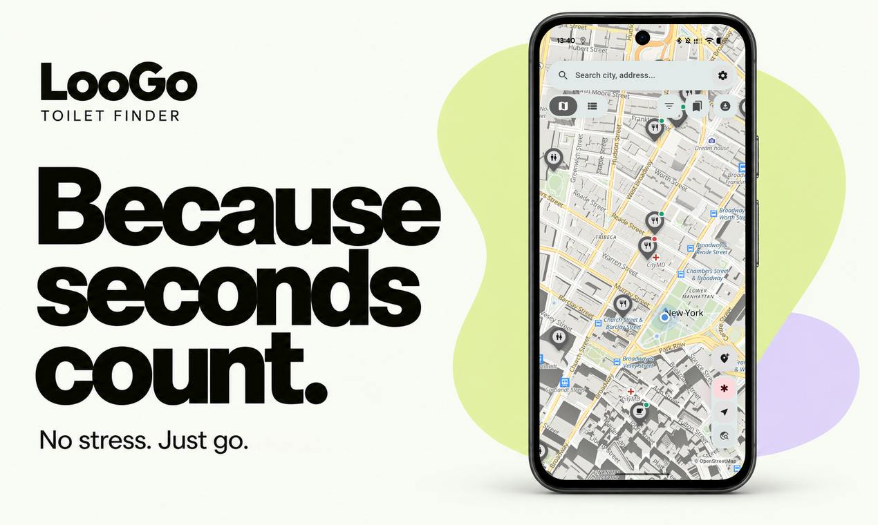
Finding a public restroom in an unfamiliar city is often an anxious affair. A recently launched Android app called LooGo, spotted on Product Hunt, tries to solve this problem in the simplest way possible: open the map, see nearby public restrooms, tap in to check access codes, prices, opening hours, and accessibility features. There are no flashy social features, no ads, and no tracking—developer Jakub Pavlů positions the product as a "fast, offline, no-frills" tool.
Core Features: Turning Public Restroom Info into Structured Data
LooGo draws its data from OpenStreetMap. This open-source mapping project already contains a wealth of public facility information, but it's hard for ordinary users to quickly filter out "restrooms I can use right now." LooGo adds a layer of productization on top: it displays nearby public restrooms directly on the map, and tapping each entry reveals details such as access codes, whether there's a fee, opening hours, and accessible entrances.
These fields may seem trivial, but they happen to be the most critical decision-making information in the "finding a restroom" scenario. Knowing the access code means you don't have to wait at the door for someone to go in or out; knowing the price means you don't have to dig for change on the spot; knowing the opening hours means you won't make a trip for nothing. According to the Product Hunt page, the app also supports offline maps, which is especially useful in travel scenarios where network signals are unstable.
OpenStreetMap (OSM) is an open-source map database maintained collectively by volunteers worldwide. It is published under an open license (ODbL), allowing anyone to freely use, modify, and distribute the data. Unlike commercial maps such as Google Maps, OSM's POI (point of interest) information relies entirely on community contributions, so coverage density varies enormously across regions. In major European and American cities, volunteers tend to annotate public facilities (including public restrooms, drinking water points, and accessible entrances) in considerable detail—sometimes even including fine-grained fields such as opening hours, fees, and access codes. In areas with lower volunteer activity, data may consist of only basic locations or may be entirely missing. For developers, OSM's advantages are zero licensing costs and freely distributable offline data packages; its disadvantage is uneven data quality and lagging updates—which directly determines the upper limit of the experience for utility apps based on OSM in different markets.
Wear OS Version: Finding Restrooms from Your Wrist
Another differentiator for LooGo is native Wear OS support. Users can view nearby public restroom locations directly on their smartwatch without having to pull out their phone. This design has obvious value in scenarios such as cycling, running, or carrying things with both hands.
From a product logic perspective, the Wear OS version is not simply a "watered-down port of the phone app" but has been adapted for the wrist scenario—lower information density and shorter interaction paths. The developer emphasizes that it is built "natively," meaning it should be able to make better use of Wear OS system capabilities rather than running as a shell.
Wear OS is Google's operating system for smartwatches and other wearable devices, formerly known as Android Wear. Compared with phones, Wear OS apps differ significantly in interaction design: screens are typically only 1.2–1.4 inches, input is mainly via voice, rotating crown, and swipe gestures, and information display must be highly streamlined. A so-called "native" Wear OS app is one built independently using Wear OS-specific UI components (such as Compose for Wear OS) that can run standalone without a phone; in contrast, a "shell" approach simply casts or mirrors the phone interface onto the watch. Native development can access the watch's independent GPS, offline storage, and low-power sensors, offering a better experience in scenarios such as running or cycling where it's inconvenient to pull out a phone—but it also means additional development and maintenance costs.
Privacy and Business Model: No Ads, No Tracking
In an environment where free utility apps commonly monetize through ads or data, LooGo explicitly promises "no ads, no tracking, no bloat." This is uncommon among similar products.
This choice also raises a direct question: how will the app sustain its operations? The Product Hunt page does not currently disclose a pricing model. Given that it is based on OpenStreetMap data, data maintenance costs are relatively manageable, but map rendering, server synchronization, and Wear OS adaptation all require investment. If a paid or donation mechanism is introduced in the future, whether users are willing to pay for a "restroom finder" tool is a point worth watching.
Multi-Source Cross-Verification: Community Feedback and Data Accuracy
It should be noted that the material for this article comes mainly from the Product Hunt product page and lacks independent third-party reviews. The figures on Product Hunt—83 upvotes, 7 comments, and a ranking of 7th—indicate that it has received some attention, but discussion volume remains limited.
A known shortcoming of OpenStreetMap data is uneven coverage: in European and American cities, public restroom annotations are relatively complete; in other regions, data may be sparse or outdated. LooGo's product experience depends heavily on the quality of the underlying data, which is a ceiling faced by all OSM-based apps. Whether the developer provides a mechanism for users to supplement or correct information is not explicitly mentioned in the page information available, and this will be a key variable affecting long-term usability.
Product Hunt is the world's largest community for launching and discovering new products. Products typically use first-day upvotes and comment counts as measures of early traction. Generally speaking, only products that receive hundreds to thousands of upvotes on the first day may enter the top ranks of the day; a result of 83 upvotes and 7th place represents a level of "some exposure but not yet mainstream breakout." Comments on Product Hunt mostly come from early adopters and fellow developers, with feedback focused on product concept and initial experience, lacking systematic feature reviews and long-term usage observations. Therefore, judging a tool's actual usability solely from Product Hunt page information has limitations—especially for dimensions that require field verification, such as data accuracy and offline coverage, which are best cross-confirmed with independent reviews or long-term user feedback.
Use Cases and Limitations
LooGo is best suited for urban travelers, commuters, and outdoor sports enthusiasts. Its advantages are being lightweight, usable offline, and not collecting data, making it suitable for privacy-sensitive users.
The limitations are equally obvious: it solves "finding known public restrooms" rather than "real-time status of restroom resources." If a restroom is temporarily closed or an access code changes, the app itself cannot detect it. In addition, being exclusive to Android and Wear OS means iOS users cannot use it.
As a utility product, LooGo's approach is restrained—it doesn't try to be a comprehensive city life guide but instead thoroughly addresses one high-frequency small pain point. This positioning often makes it easier to earn word-of-mouth in the app market, but it also determines its growth ceiling.
One-line Summary
LooGo uses OpenStreetMap data to help Android and Wear OS users quickly find nearby public restrooms.
Paragraph Summary
LooGo is an Android app that debuted on Product Hunt, aiming to ease the anxiety of finding public restrooms in unfamiliar cities. Based on OpenStreetMap data, it displays nearby public restroom locations, access codes, prices, opening hours, and accessibility features in a structured way on the map, and supports offline maps. The product also natively supports Wear OS, making it convenient for scenarios such as cycling and running where it's inconvenient to pull out a phone. LooGo explicitly promises no ads and no tracking, making it privacy-friendly, but its business model is not yet clear. Its experience depends heavily on the quality of OSM data coverage, usability is limited in data-sparse regions, and it supports only the Android ecosystem, so iOS users cannot use it.
Related articles

WorkBuddy Full Tutorial: Build an AI Office Automation Agent from Scratch
A complete WorkBuddy tutorial: installation, three working modes, multimodal picture book video practice, expert team agent building, and workflow configuration for low-cost AI office automation.

WorkBuddy Agent Complete Guide: From Beginner to Automation in 7 Days
Based on Bilibili's 256-episode WorkBuddy masterclass, this systematically breaks down Tencent's AI office workbench core capabilities: Agent principles, Skill encapsulation, cross-platform connectors, scheduled automation, knowledge bases, and zero-code development, with learning path recommendations.

8 AI Accounts, 7 Failed: An Honest Review of Using AI to Get Work Done
Only 1 of 8 AI-run Bilibili accounts succeeded. We break down the real difference between "performing AI" and "using AI to get work done."