Astrophysicist Creates First Full Ultraviolet All-Sky Map with Claude in Days
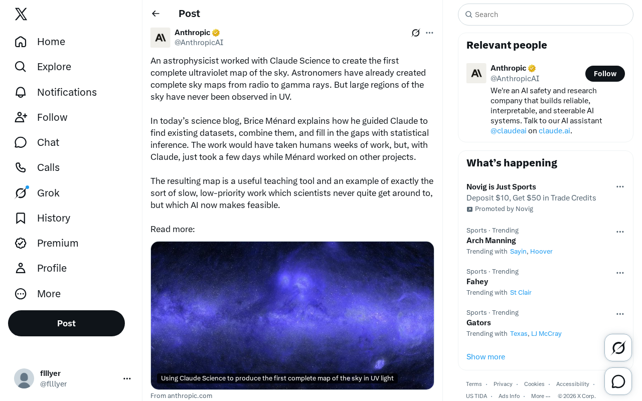
An astrophysicist used Claude to integrate scattered UV data and generate the first complete ultraviolet all-sky map in days.
Astrophysicist Brice Ménard, working with Claude Science, produced the first complete ultraviolet all-sky map. The UV band has long had large unobserved gaps because telescope time is fiercely competitive, and low-priority tasks like completing an all-sky map never make the schedule. Ménard had Claude retrieve scattered existing UV datasets, verify coordinates, unify calibration, handle overlapping regions, and statistically infer unobserved areas. Work that would take weeks was done in days. The map is positioned as a teaching tool, but its greater value is validating a viable AI workflow for multi-source heterogeneous data integration and clearing research backlogs.
Astronomy has long had complete all-sky maps from radio to gamma rays—every band except ultraviolet, where large swaths of the sky have never been observed. Astrophysicist Brice Ménard, working with Claude Science, filled in that missing piece: the first complete ultraviolet all-sky map, created in just a few days.
The ultraviolet gap: a long-shelved task
Multi-wavelength astronomy is a mature paradigm. Radio, infrared, optical, X-ray, and gamma-ray observations all have complete or near-complete sky maps, and these datasets underpin a great deal of cross-band research. Ultraviolet is the exception: vast regions of the sky have never been observed, for a very practical reason—observing resources are limited and competition for telescope time is fierce. No one wants to spend precious telescope hours on a low-priority task like "completing a map."
In a post on Claude's official science blog, Ménard describes his approach: he had Claude search existing scattered ultraviolet datasets, stitch them together, and then use statistical inference to fill in regions with no observational data at all. In other words, this map wasn't "photographed"—it was "computed."
The core idea of multi-wavelength astronomy is that celestial objects radiate information about different physical processes at different wavelengths; only by stacking data from radio, infrared, optical, ultraviolet, X-ray, and gamma-ray bands can you assemble a complete astrophysical picture. Radio, for example, reveals synchrotron radiation and cold gas, X-rays reveal hot plasma, and the ultraviolet band is especially critical for tracing young stars, ionized gas, and interstellar dust. An all-sky map is a dataset that projects the entire celestial sphere onto a single image, typically assembled from patchwork survey observations. Because detectors for different bands work on vastly different principles, all-sky maps vary widely in coverage and resolution. The ultraviolet band, severely absorbed by the atmosphere and therefore dependent on space telescopes, has scarce observing opportunities—making it the largest gap in the multi-wavelength puzzle.
Claude's role: data scout and assembler
Ménard emphasizes that the difficulty wasn't in the modeling approach but in execution. Finding existing datasets scattered across various sources, verifying their coordinates and calibration, handling systematic differences in overlapping regions, and statistically filling in missing areas—this kind of work is repetitive, tedious, and error-prone, and would take a human weeks.
He handed these steps to Claude while continuing to advance other projects, completing the whole effort in a few days. This detail is worth noting: AI here didn't replace the scientist's judgment—it replaced the mechanical labor that scientists "have always wanted to do but never had time for." Ménard controlled the logical direction—finding data, stitching data, inferring and completing—while Claude took on the heavy execution.
This also explains why the author characterizes the result as a "teaching tool." Its value lies not entirely in the scientific output itself, but more in demonstrating a viable workflow: one person plus one AI assistant, completing cross-dataset integration in days that would previously have taken weeks.
Technically, integrating multi-source heterogeneous data involves several key steps: first, metadata retrieval—locating available ultraviolet images and catalogs from different archives (such as MAST and VizieR); second, coordinate unification—reducing maps from different epochs and projections to a common celestial reference frame; then photometric calibration and background subtraction to eliminate systematic biases from instrument differences; and finally statistical filling, with common methods including Gaussian process regression based on correlations with neighboring sky regions, sparse representation, or deep learning generative models. Individually, none of these steps is complex, but combined they are extremely sensitive to detail—a single coordinate error or calibration bias will leave artifacts at the seams. Claude's value lies in quickly writing and debugging processing scripts and batch-verifying file header information, automating a process that previously required repeated manual comparison.
Why this matters beyond a single astronomical map
The collective neglect of low-priority work is a structural problem in the research system. Scientists generally know what should eventually be done—it just never makes it onto the schedule. This is where Ménard locates AI's value: not sprinting at the frontier, but clearing the backlog.
This case offers two lessons. First, it validates AI's ability to handle multi-source heterogeneous data integration: retrieval, cleaning, stitching, and statistical completion—each step demands accurate handling of data details, and an error will contaminate the entire map.
Second, it demonstrates a new division of labor in scientific collaboration. Human value concentrates on problem definition, methodological judgment, and result verification; AI takes on the data-level grunt work. This division of labor may be more realistic—and arrive sooner—than the narrative of "AI proposing scientific hypotheses."
Of course, regions filled in by statistical inference are not real observations. The author himself positions the map as a teaching tool, which is a different matter from treating it as authoritative data ready for quantitative research. Future actual observations will test the reliability of these inferred regions, and perhaps the map's first-order significance is simply letting astronomers visually see "what exactly we're missing."
Quick summary
- Brice Ménard used Claude to retrieve and integrate existing ultraviolet datasets and fill unobserved regions with statistical inference, producing the first complete ultraviolet all-sky map.
- Comparable work would take a human weeks; with Claude, it was completed in days.
- The map is positioned as a teaching tool, and its greater value lies in demonstrating the feasibility of AI handling low-priority, multi-source data integration tasks.
Related articles

Free Unlimited Claude Code Solution: Agnes AI + CC Switch Setup Guide
No paid subscription needed — pair the free AI platform Agnes AI with the open-source tool CC Switch to provide a backend for Claude Code, enabling unlimited free calls to text, image, and video models. This guide covers the full setup, test results, and usage boundaries.

A Complete Zero-Cost Guide to Getting Started with Claude Code for Beginners in China
A beginner's guide to Claude Code for users in China: two installation methods (command line and IDE plugin), full configuration steps for replacing the official API with the free domestic LongCat model, and a hands-on demo of building a small tool with natural language, plus tips.

When the NSA Gets Involved: The AI Supply Chain Crisis Behind Open-Source CVEs and API Key Hijacking
Multiple open-source projects disclosed severe CVEs in one day, PHP flaws alarmed the FBI, and Railway and OpenCode were breached with API keys stolen. This article breaks down the vulnerability window, AI-accelerated exploitation, and the AI supply chain crisis behind the API key black market, with a developer defense checklist.